|
High in the Rocky Mountains of Mount Robson Provincial Park, trickles of glacier-fed water flow together to form the humble beginnings of the mighty Fraser River. These waters will flow approximately 1370 km over widely varied terrain, from the rugged Rocky Mountain Trench through the gently rolling Interior Plateau and into the Fraser Valley on the lower mainland before finally pouring into the ocean at Vancouver.
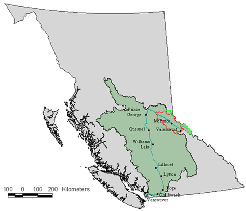
Location of the Fraser River drainage basin (green) and the Fraser Headwaters study area (outlined in red) within British Columbia.
The Fraser River watershed is a complex system that provides many ecosystem services: clean drinking water for its many human inhabitants, spawning grounds for salmon, critical habitat for many other species, and cultural and heritage areas. The health of the river is dependent on the health of the ecosystems through which it flows-mountains, forests, and plains. The Fraser Headwaters, birthplace of the river, is a critical part of the watershed; what happens here will affect ecosystems downstream.
Working with the Fraser Headwaters Alliance, a non-profit grassroots conservation organization based in the Robson Valley, the Silva Forest Foundation prepared landscape-level ecosystem-based mapping for 1.3 million hectares (13,000 km2) in east-central British Columbia close to the BC-Alberta border. The study area runs approximately parallel to the Rocky Mountain Trench, stretching from Valemount in the southeast to Sinclair Mills in the northwest, and from the height of land in the Rocky Mountains down across the trench and up to the height of land in the Columbia Mountains.
The project was exciting for a number of reasons. First, maintaining the health of the headwaters is critical to ensuring the ecological integrity of the Fraser River, one of the last wild large salmon-spawning rivers in North America. Secondly, the headwaters is surrounded by a number of large protected areas: Mount Robson, Willmore, and Kakwa Wilderness Provincial Parks, with Jasper National Park to the northeast in the Rocky Mountains; and Bowron Lake, Cariboo Mountains, and Wells Gray Provincial Parks to the southwest in the Columbia Mountains. As presently configured, these parks are not sufficient to protect the ecological functioning of the Fraser Headwaters, but if connected through a network of smaller core reserves and corridors, they provide the ideal starting point for ecosystem-based management. Finally, this was the first project undertaken by the Silva Forest Foundation over such a large area. Ecosystem-based conservation planning provides for nested networks of ecological reserves at multiple scales. The Fraser Headwaters provides the opportunity to integrate ecosystem-based plans done at different spatial scales because SFF has previously completed ecosystem-based mapping for two watershed areas of approximately 100,000 hectares each within the larger Fraser Headwaters area.
Six maps were produced as part of the Fraser Headwaters analysis and plan:
(Note that the detail of the original, full format (45" x 36") maps is not visible on the web versions.)
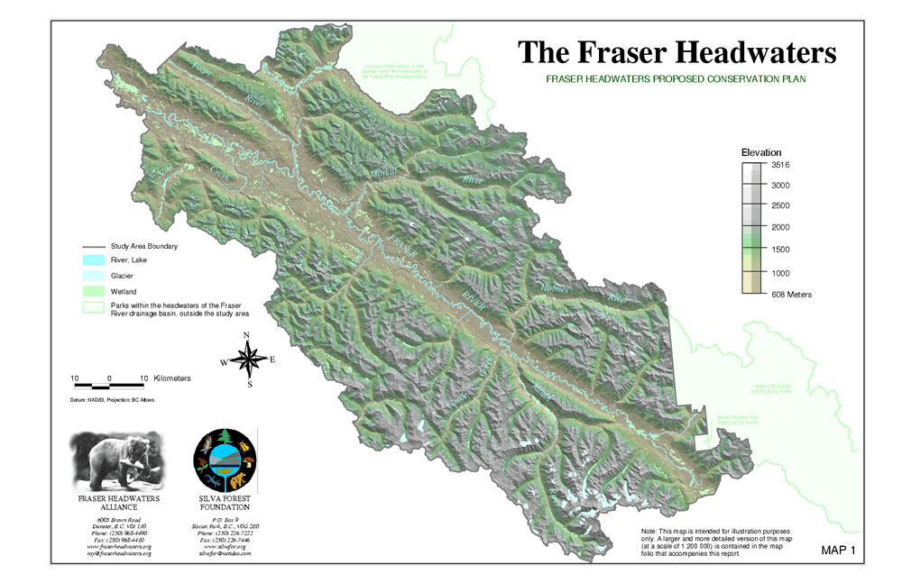
Map 1: The Fraser Headwaters highlights the topography of the area and illustrates the very rugged mountainous landscape. One-third of the area lies above treeline; a further third is composed of high elevation forests. Cold climate, heavy snowfalls, thin soils, and steep terrain are major ecological limits.
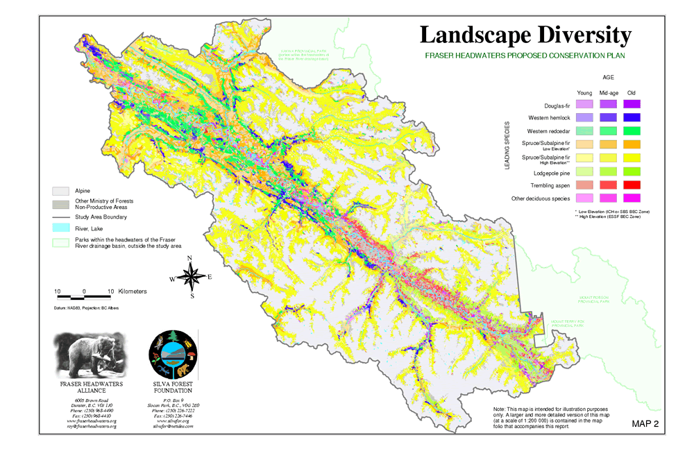
Map 2: Landscape Diversity shows the distribution of forest types in the Fraser Headwaters. The highest diversity is found at lower elevations within the Rocky Mountain Trench. Most of the side valleys are less diverse, although exceptions to this pattern occur in a few places, such as the Raush River Valley.
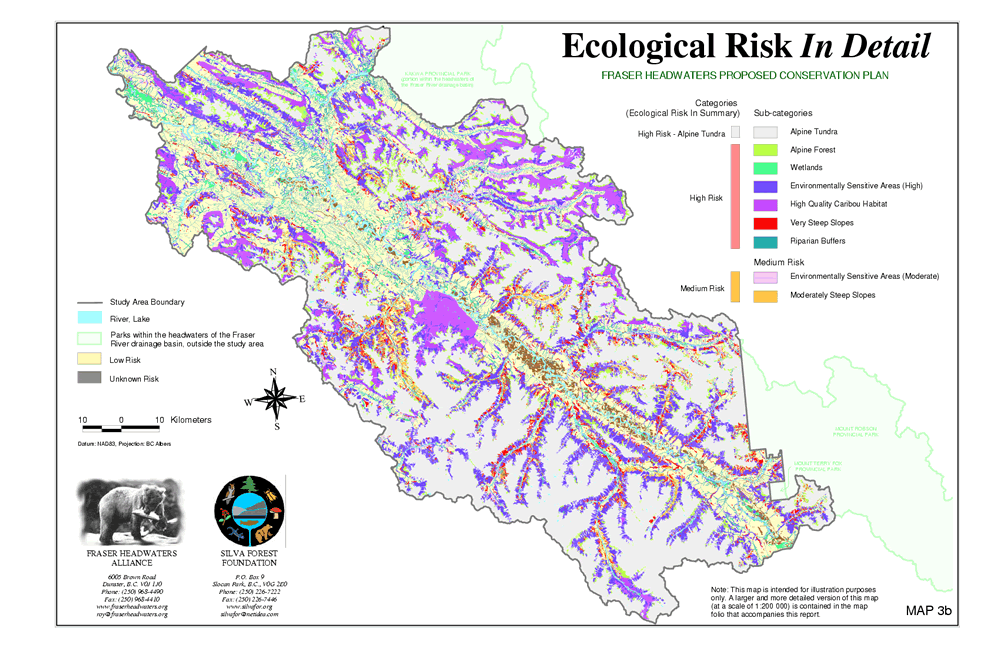
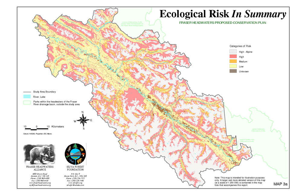
Map 3a: Ecological Risk In Detail and Map3b: Ecological Risk In Summary show areas with high sensitivity to disturbance, such as wetlands, steep slopes, high quality caribou habitat, and riparian ecosystems. Over 70% of the study area was identified as high ecological risk.
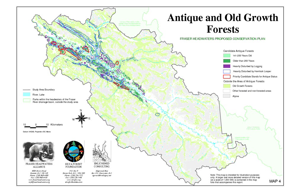
Map 4: Antique and Old-growth Forests highlights the location of the oldest forest stands within the Fraser Headwaters. Over 60% of the forests are old growth. The oldest of these forests, located in very humid locations at low elevations, are termed antique forests. Unique to British Columbia, and perhaps North America as a whole, antique forests have not undergone stand replacing natural disturbances since glaciations and function as biological storehouses and centres of dispersion of biological diversity.
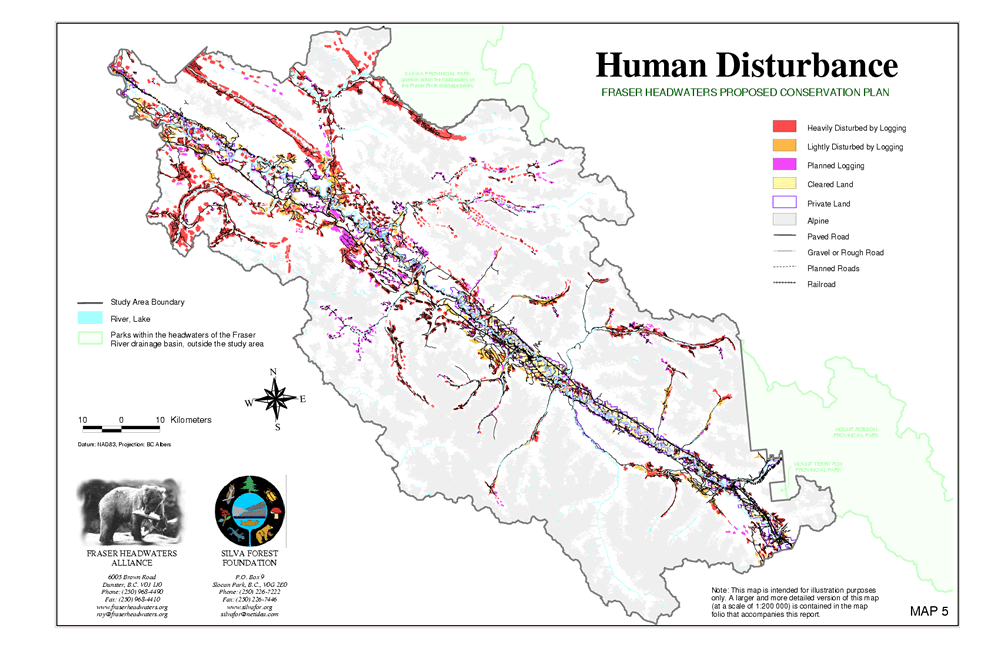
Map 5: Human Disturbance shows the extent of human activity on the landscape, including past and planned logging, roads, railroads, and cleared and private land.
Map 6: Protected Areas Network (PAN) synthesizes the information and analysis presented in Maps 1-5. The PAN shows those areas that must be set aside from industrial development in order to protect ecosystem functioning at the landscape level. The PAN includes two main components: Proposed Full Protection and Proposed Conservation Emphasis.
The Proposed Full Protection areas include a corridor along the Rocky Mountain Trench protecting the antique forests, and two major linkages connecting the Rocky and Columbia Mountains across the trench. The first linkage runs from the Raush River valley across the Fraser and up the Chalco Creek drainage. The second linkage includes the Goat River and the lower Morkill River watersheds. These linkages promote movement of plants, animals, and micro-organisms through the Fraser Headwaters area and between the large protected areas that border it on both sides.
The Proposed Conservation Emphasis areas buffer the Full Protection areas, provide protection for representative and unique ecosystems, and provide additional connectivity in the landscape. Although they do not require full protection, more stringent ecosystem-based guidelines for human use will need to be developed for these areas. Several main Conservation Emphasis areas were identified: a long corridor extending the length of the Rocky Mountain Trench, which will facilitate species movement along the Fraser; and a loop following the lower Morkill, upper McGregor, and lower Torpy Rivers, which will maintain the flow of species and energy between the McGregor and Fraser River systems.
Areas that fall outside the PAN require further ecosystem-based conservation planning at the watershed level. Such planning has already been carried out by the Silva Forest Foundation for two watershed units within the Fraser Headwaters: Horsey Creek/Small River/Kiwa Creek, and Raush River. Designation of human use areas and more detailed planning can now proceed in these two areas, while further ecosystem-based planning at the watershed level needs to be carried out in all areas not protected within the PAN.
What does the future hold for the Fraser Headwaters? Ultimately, maintaining the ecological integrity of the Fraser Headwaters will depend on the commitment of local communities to adopt an ecosystem-based approach and adapt it to local values and needs.
|


