|
The Slocan Valley Ecosystem Based Plan was completed in 1996. It was our first completely GIS-based planning project. The project was carried out in the days of pen plotters and cross-hatched maps, unlike the solid fill maps now produced in our ink jet plotters. While the cross hatched maps look "old fashioned" by today's standards, our maps have changed over time, along with the technologies used to produce them. However, Mmny of the concepts and approaches to landscape planning with GIS which we still utilize can be traced directly back to the "Slocan Valley Plan".
The Slocan Valley Ecosystem-Based Plan covers the watershed of the Slocan River, which consists of 331,-28 hectares of interior rain forests. In order to facilitate data analysis and planning, the Slocan River watershed was subdivided into nine sub-watershed units.
The interpretive map set was produced for each of the sub-watershed units at a 1:5000 scale. Valhalla Park, which constitutes the north sub-watershed unit, was considered a large protected area, and was not mapped in detail for this plan.
An interpretive map set was also produced for the entire Slocan River watershed at a scale of 1:125,000.
For illustration purposes in this summary, the mapping for the “Hills” sub-watershed unit has been used. Map descriptions apply to the corresponding map for each sub-watershed unit.
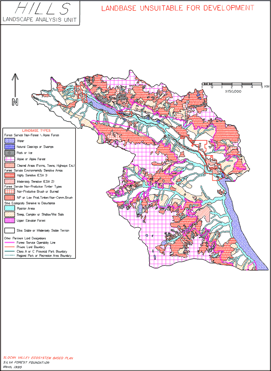
Map 1. Landbase Unsuitable for Development
Map
The Landbase Unsuitable for Development maps show the areas which have been removed from the potential timber management landbase by the B.C. Ministry of Forests (MoF) and by the SFF due to ecological sensitivity. Sites that are too steep, too wet, too high in elevation, too dry; that have shallow soil; or that suffer other significant limitations to tree growth are "netted out" of the landbase.
The map is hierarchical. All ecologically sensitive land identified by the MoF is removed from the timber management landbase first, followed by additional ecologically sensitive areas idintified by the SFF. We take a more precautioanary, less risky view of ecological sensitivity than the government and industry, so we usually identify as sensitive and wish to protect more of the landbase from industrial resource exploitation than the MoF or the timber industry. The white spaces left on the map indicate areas of stable, moderately stable or helicopter accessible terrain which may be suited for timber management, or which may be required for other uses, such as water protection or wildlife habitat.
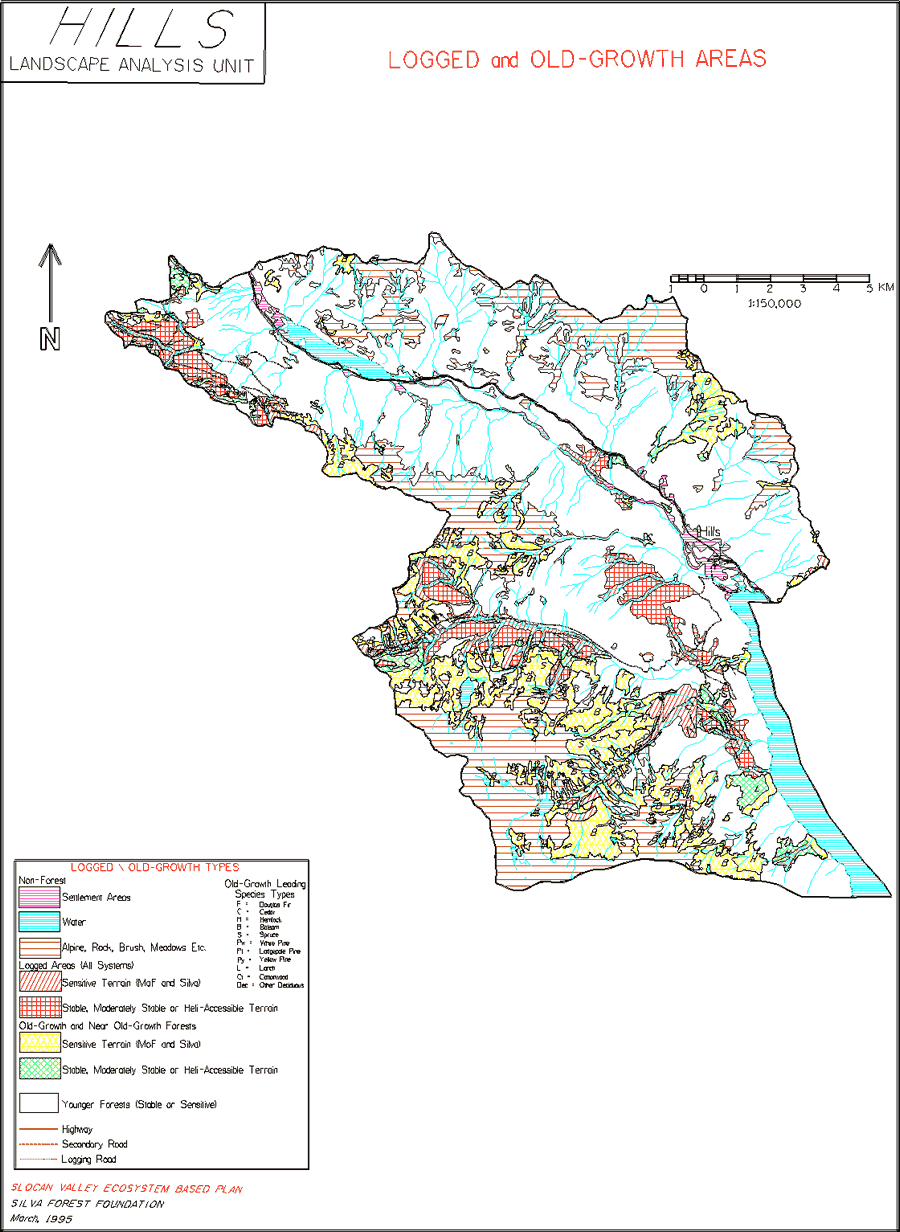
Map 2: Logged and Old-growth Areas
Map
The Logged and Old-growth Areas maps show the distribution of remaining old-growth forests in the study areas. Old-growth forests are critical ecological resources, providing the only habitat for numerous species, many of which are rare, threatened or endangered. They are also ecological storehouses, which are needed in order to maintain "managed" forests. We believe that old-growth forests occupied at least 50% of the Slocan Valley landscape prior to European settlement, although the exact figure is impossible to determine after a century of burning, mining, settlement and logging. The maps shows how little old-growth forest remains. The maps also divide the remaining old-growth forest by leading tree species and site sensitivity. Very little Douglas-fir, western red cedar and western hemlock old-growth forest on stable and moderately stable, lower elevation sites remains. This distinct ecotype has been greatly depleted by logging, clearing for settlement and human-caused fire. Only higher elevation Engelmann spruce, sub-alpine fir, and lodgepole pine old-growth forests on cold, harsh, ecologically sensitive sites are still "common" in some watersheds, and these are being actively depleted by logging.
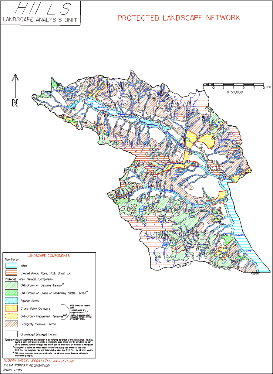
Map 3: Protected Landscape Network
Map
The protected areas identified outside of ecologically sensitive areas are contentious. The forest industry would prefer to protect only sensitive terrain with low timber productivity and/or difficult access. However, we believe it is necessary to protect representative portions of all ecosystem types, including stable, high quality timber growing sites, in order to maintain healthy forest landscapes and wildlife populations, and human societies. This requires that representative ecosystems be well distributed across the Slocan Valley landscape.
This map shows the protected landscape network (PLN) which we have designed. The objective of the PLN is to maintain forest ecosystem integrity and natural forest functions at the landscape level in forest landscapes that are impacted by human use. The PLN is generally composed of the following components:
- Old-growth Forests on Stable Terrain. Less than 30% of the stable and moderately stable terrain in all parts of the Slocan Valley is now covered by old-growth forests, a proportion which we believe is well below the historical range of variation of old-growth cover. We therefore included all remaining old-growth forests on stable terrain in the PLN, in order to protect what remains of this critical ecological resource.
- Old-growth Forests on Ecologically Sensitive Terrain. All ecologically sensitive terrain is to be protected from resource extraction. These sites are classified separately on the map to highlight the amount of old-growth forest remaining.
- Riparian Ecosystem Corridors. These corridors extend along all streams, and include both the moist streamside ecosystem or floodplain and a strip of drier upland forest in the riparian zone of influence.
- Cross Valley Corridors. These corridors climb hillsides to find natural passes and travel routes, in order to increase landscape connectivity and protect an elevation range of habitat types. 5. Old-growth Recruitment Reserves. Less than 15% of the stable and moderately stable terrain in some lower elevation biogeoclimatic types is currently covered by old-growth forest. Old-growth recruitment reserves were identified to increase the area of old-growth forests in these ecotypes as quickly as possible.
- Ecologically Sensitive Terrain. All ecologically sensitive terrain is protected from resource extraction in this plan, so the ES terrain is effectively part of the protected landscape network. This decision is a practical application of the precautionary principle.
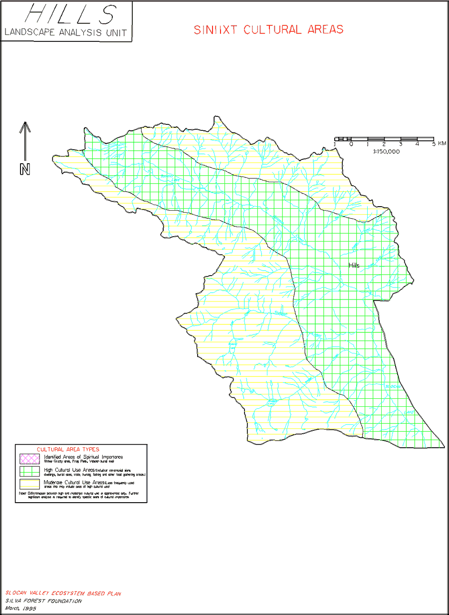
Map 4: First Nations Cultural Areas
Map
This type of map is prepared at the discretion of, and with the assistance of First Nations in any landscape where SFF prepares an ecosystem-based plan. Issues such as ongoing land claims and treaty negotiations may make idenification of traditional use areas and patterns a culturally and politically sensitive issue for First Nations.
SINIIXT CULTURAL ZONES
Prepared by Marilyn James of the Siniixt First Nation
Siniixt traditional territory includes but is not limited to the proposed mapping of the Siniixt Cultural Zones. The Siniixt purpose of zoning as proposed in the Slocan Valley Mapping project is being done for the following reasons:
1. To illustrate the historical and current importance of the land to the Siniixt.
- There are archeological studies that depict the Siniixt connection to their traditional territory for a period of time no less than five thousand (5,000) years.
- The area known to us as Frog Mountain and to others as Airy Mountain has great significance to the Siniixt as it directly relates to its (the mountain’s) creation as a land survival history of the Siniixt Peoples.
- Another area specifically named as an identified area in the cultural zoning and listed as an area of spiritual importance to the Siniixt is the White Grizzly area. The White Grizzly are sacred to the Siniixt in their belief system and have great significance in the Siniixt connection to their land on a spiritual level. To destroy any part of the White Grizzly habitat would be to undermine spiritual beliefs.
- Identified burial sites such as the Vallican Site, are important to protect for all of the obvious reasons. The Siniixt people have repatriated and reburied fifty-two (52) complete and fractured skeletal remains of the Siniixt ancestors. It is a belief of the Siniixt that there is a cultural law that states that, when one dies, the physical form must return to the earth. When the physical form of a human is not allowed to return to the earth then the law is being broken and the person whom the remains represent must be vindicated. The only clear way that the living can rectify the mistake is to return the remains to the earth and let the law be followed
2. Zoning reflects the need to protect identified specific cultural sites and areas.
- To allow for protection in a specific area but not to delete the possibility that other sites may exist.
- Once an area is determined for development and that development will occur in a cultural zoning area this will create the opportunity for research teams to reconnaissance areas and identify specific sites if they exist in the specified development area.
3. To allow for protection of cultural sites yet to be determined.
- Once an area is determined for development and reconnaissance has identified a specific site, the importance of the site will be determined and will create the protection value of the site.
- Zones which have been depicted in the mapping process have been identified in three modes:
- Identified Areas of Spiritual Importance
- High Cultural Use Areas
- Moderate Cultural Use Areas
The zoning boundaries as identified in the mapping process may fluctuate. As an example, there may be areas in the moderate cultural use areas which have not yet been identified but may be reclassified as High Use or Areas of Spiritual Importance. The identified areas of spiritual importance are areas that require the highest level of protection and cannot be compromised. The other two areas allow for reconnaissance and a determination of protection value priority.
4. To initiate current and future required participation of the Siniixt in all land use planning.
- Siniixt people are requiring an opportunity to reconnaissance areas designated for development to inventory and identify cultural sites that may or may not require protection.
- There is an ongoing process which may determine that the Siniixt people will have some specific land claims in their territory in the future and will require participation on other levels. Involvement on this level now will make the transition into that process expeditious.
5. To encourage that land use and development be proper, encompass, and include all sector interests.
- When the value of interests are determined in the land use planning process the ultimate goal would be to create a higher value of protection for those areas that are of interest to more than one sector.
The development of and the inclusion of cultural zoning is an important step in providing useful information for fair, just land use decisions. The expectation of the Siniixt is that this aspect of land use planning will not be ignored. Our hope is that the cultural zoning will be part of a local, shared decision-making process for land use in the Slocan Valley.
Map 5: Wholistic Forest Use Zones
Map
These maps show human use zones which were identified in the areas between the components of the protected landscape network, and in some parts of the protected landscape network. In human use zones, all activities need to be carried out in ecologically responsible ways. Each human use zone is assigned a priority use which sets the terms under which other uses may be carried out. For example, commercial tourism zones may include areas used for ecologically responsible timber extraction. However, all timber extraction in such zones must protect all aspects of the zone that are valuable for current and future tourism activities.
Because some of the zones may overlap, the total area of all Wholistic Forest Use zones generally exceeds the total area of the landscape analysis unit.
General principles for ecologically responsible forest use and specific standards for ecologically responsible timber management may be found in SFF’s Eco-Cert standards for ecosystem-based forest management. [link to Archives-Eco-Certification]
Human use zones were identified through consultation with several sectors represented in the Slocan Valley CORE Pilot Project. All sectors were invited to participate in three consultation sessions carried out by the Silva Forest Foundation, although some chose not to participate.
Human use zones proposed for establishment in this ecosystem-based plan include:
Siniixt Cultural Zones
As explained previously, Siniixt Cultural Zones cover the entire Slocan River watershed. All forest uses, including large protected areas, are subject to a just and lasting settlement of the land question. In the interim, Siniixt culture and land will be protected throughout the Slocan Valley by taking direction from the Siniixt Nation. The three Siniixt Cultural Zones are:
- Identified Areas of Spiritual Importance
- High Cultural Use Areas
- Moderate Cultural Use Areas
Consumptive Use Watersheds
These are small watersheds within the larger Slocan Valley watershed/landscape that supply water for domestic and agricultural purposes to human settlements largely in the main valley floor. Some aspects of activities such as timber management, mining, commercial tourism, outdoor recreation, and wildcrafting pose an unacceptable risk to water quality, quantity, and timing of flow of water supplies, and are not acceptable in these consumptive use watersheds. Specific risks include introduction of sediment into water supplies, destabilization of stream channels, deeper snowpacks and more rapid snowmelt in logged areas, and introduction of human waste into watershed areas. Future planning must identify specific standards for ecologically responsible activities that are appropriate for consumptive use watershed zones.
Headwaters Protection Zones
The headwaters areas of consumptive use watersheds regulate water quality, quantity, and timing of flow throughout the watershed. These areas are the storage basins in a watershed, and are often wet and ecologically sensitive. Headwaters areas often contain patches of old-growth forests that are particularly important for water storage and filtration. For these reasons, human activities are excluded from headwaters protection zones.
Large Protected Areas
Existing and proposed protected areas are shown as zones within this ecosystem-based plan. These large reserves provide critical reservoirs for ecological communities, species, and genetic diversity. Protected areas are essential blueprints of fully functioning ecosystems which may provide a template for restoring degraded ecosystems in portions of the landscape degraded by human activities. Other than small-scale, minimal impact recreational and tourism activities, no human uses are permitted within protected areas. We hope that the combination of existing protected areas, two proposed protected area extensions, and establishment of the protected landscape network will enable the Slocan Valley landscape to withstand future changes and stresses, both human-induced and natural.
Commercial Tourism Zones
SFF used information from the Tourism sector to establish commercial tourism zones in various areas throughout the Slocan River landscape. Ecologically responsible timber management is permitted within Stable, Moderately Stable, and Heli terrain within commercial tourism zones subject to the needs of commercial tourism operators. Because ecologically responsible timber management maintains the composition, structure, and function of natural forests, we have assumed that ecologically responsible timber management can occur within some portions of commercial tourism zones. However, the exact nature and extent of timber management in tourism zones will require ground truthing and the approval of affected commercial tourism interests.
Potential Wholistic Timber Zones
These are areas of stable or moderately stable terrain located throughout the landscape of the Slocan Valley. Where these areas can (likely) be accessed by road in an ecologically responsible manner, logging systems that employ roads are planned. Where ecologically responsible ground access does not appear possible, potential wholistic timber zones are designated as “heli”. Any timber extraction in these area must be carried out with aerial logging systems, such as helicopters, that do not require the construction of on-site roads.
In order to minimize negative impacts of timber extraction, timber cutting must be planned and carried out on a “watershed-specific” basis. Annual allowable cutting rates must be developed for each particular watershed. Without this approach, timber cutting activities will systematically over cut each watershed within the Slocan River landscape, resulting in short- and long-term degradation of ecosystem functioning.
Wholistic timber management is carried out by ecologically responsible partial cutting or very small patch cutting. All ecologically responsible timber cutting requires permanent reservation of large trees, large snags, and large fallen trees, well distributed spatially and by species throughout a logging unit.
For the purposes of this plan, a minimum of 25% of the timber yield is permanently reserved in large trees, well distributed spatially and by species, that are left on each site to grow old and die. Eventually, as permanent leave trees die, replacement trees will be designated, ensuring that a suitable population of large old trees will always be maintained.
Individual cuts will seldom remove more than 10-15% of the trees and will be separated by at least 15 years. Roads are small (less than one-half the width of conventional timber cutting roads) and fit into the terrain. For these reasons, wholistic timber management can be carried out in some portions of other zones and in small portions of the protected landscape network.
To estimate an ecologically sustainable annual allowable cut (AAC) for potential timber zones within the Slocan River landscape, we made assumptions as to what portion of timber zones will be available for ecologically responsible timber cutting. These assumptions reflect the need to protect ecosystem composition, structure, and function at the site level, to protect non-timber zones where timber extraction may occur, and to recognize the initial nature of this planning process (i.e. be precautionary). The assumptions made regarding the availability of land for timber cutting within Wholistic Forest Use Zones is shown in the table below:
Restoration Zones
By removing or falling all or nearly all large old trees and snags, and removing or damaging large fallen trees, clearcuts degrade and may destroy forest functioning at the patch or stand level. In addition to this loss of structure, roads (which are linear clearcuts), landings, and skid roads degrade soil, cause soil erosion, including landslides, and damage water quality. Removal of all large trees in an area results in higher spring runoff, which scours stream channels, causes siltation of streams, and contributes to erosion, landslides, and debris flows. Clearcuts, particularly extensive clearcutting in a landscape, result in loss of plant and animal habitat, and local extirpation of plant and animal species.
Therefore, all existing clearcuts in the Slocan River watershed are classified as Restoration Zones. Depending upon their location in relationship to old-growth fragments and cross valley corridors; and the need for old-growth recruitment, Restoration Zones are subdivided into:
- Restoration/Protect—Following forest restoration, these areas will be added to the protected landscape network.
- Restoration/Potential Wholistic Timber Zones—These are clearcuts which have occurred on stable and moderately stable terrain, and are in areas that are not needed for the protected landscape network. Therefore, once natural composition, structure, and functioning are restored to these sites, they may be used for ecologically responsible/wholistic timber management.
Forest restoration is the price of timber exploitation. However, employment from forest restoration activities is an important part of the economic transition strategy for moving from an externally controlled, non-sustainable economy to a locally controlled, sustainable economy.
Settlement Patterns
The extensive clearing of the riparian ecosystem of the Slocan River and of portions of the riparian ecosystem of the Little Slocan River for settlement purposes has greatly modified and degraded the overall functioning of the Slocan River landscape. No other ecosystem types within the Slocan River landscape can substitute for the riparian ecosystem of the Slocan River. The Silva Forest Foundation recommends that planning and carrying out the restoration of the Slocan River riparian ecosystem be a high priority for communities and rural areas in the Slocan Valley.
We understand that this issue is complicated because nearly all of the riparian ecosystem of the Slocan River is privately owned. Means must be developed to work with private landowners in the restoration of riparian ecosystem functioning. Such restoration meshes with the needs of many interest groups and will improve water quality, wildlife habitat, fish habitat, forest landscape and stand level functioning, and agricultural pest control. Restoration of the Slocan River riparian ecosystem would be eligible for funding under Forest Renewal B.C., and could provide a model of cooperation between private landowners, public interest groups, and provincial agencies.
|


