|
Introduction
The Harrop-Proctor ecosystem-based analysis and ecosystem-based forest-use plan was completed in 1998 for the Harrop-Procter Watershed Protection Society (HPWPS). In 1999 the HPWPS was awarded a Community Forest Pilot Agreement for community management of their forests. The community successfully completed the five year pilot and has now been granted at 25 year licence.
The stated watershed management objectives of the HPWPS include:
- to achieve ecosystem-based forest management in the Harrop-Procter area which will benefit the community in perpetuity.
- to ensure that forest use activities, particularly timber management, protect water quality, quantity, and timing of flow in both the short and long terms.
- to promote a sustainable, community-based economy through ecosystem-based forestry planning, ecologically responsible timber management activities, the enhancement of local processing facilities, and the development of value-added wood manufacturing.
- to develop appropriate non-timber forest uses of the Harrop-Procter watersheds. Non-timber forest uses under consideration include, but are not limited to: wildcrafting, nature interpretation, wildlife viewing, tourism, and existing trap lines.
- to establish a water monitoring program in the Harrop-Procter watersheds in order to evaluate the results of ecosystem-based forestry, and to ensure that timber management does not degrade water supplies.
The purpose of our ecosystem-based analysis was to assist land use planning and estimating ecologically sustainable timber flows. We did not carry out operational planning. Future work will add to and enhance this initial assessment. The current work is a starting place from which the community can move forward towards sound ecosystem-based forest management.
The study area is the series of small watersheds on the south shore of the west arm of Kootenay Lake above the communities of Harrop and Procter. The communities of Harrop and Proctor have a year-round population of 800 people living on the west arm of Kootenay Lake.
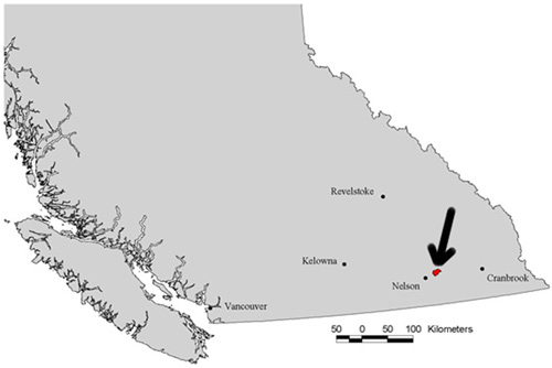
Location of the Harrop Procter study area within southern British Columbia.
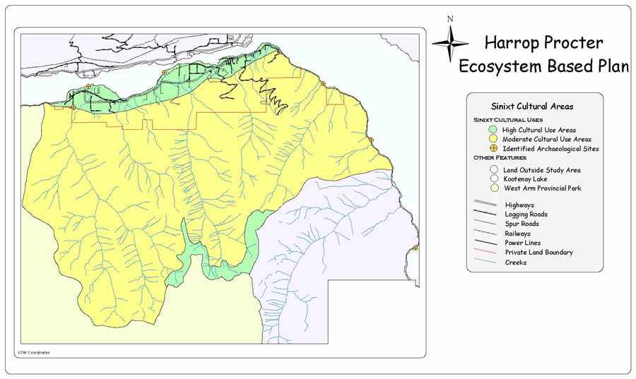
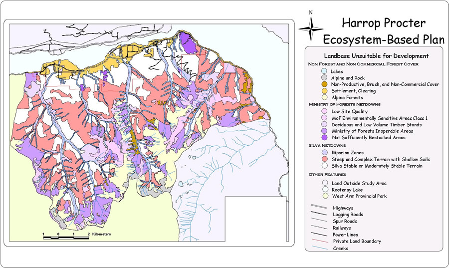
Cultural Areas
Map
The HPWPS contacted the Ktunaxa Kinbasket Tribal Council and the Sinixt First Nation to request information on past First Nations use and activities in the Harrop-Procter watersheds. Material from the Ktunaxa Kinbasket Tribal Council was not available in time to be included in this report.
The Sinixt provided the information used to prepare the map. They identified a set of archaeological sites along the shore of Kootenay Lake, and important use sites along the open alpine ridge crests and the flat lower Kootenay Lake valley slopes.
There is little conflict between the forest management proposals in this Ecosystem-based Plan and the First Nations Uses shown. However, there is overlap between the Sinixt high use zone along the lower slopes beside the West Arm and current settlement patterns. While settlement and land question issues are outside of the scope of this plan, they need to be addressed by the communities involved.
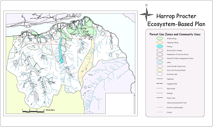
Current Land Use
Map
Current land uses in the study area were identified during a series of meetings with the HPWPS. Human settlement occupies the lower elevation portions of the study area, while in the upper, backcountry portions of the Harrop-Procter watersheds, the forests provide water for consumptive use. Three-quarters of the community relies on surface water from the area for domestic and agricultural water supplies. Other use areas included wildcrafting, camping, hiking, fishing and grizzly bear viewing.
Human access to most of the watersheds is very limited at this time. Vehicle access is restricted to the lower slopes of the main Kootenay Valley; no roads penetrate into the side valleys. A rail grade runs along the lakeshore throughout the study area. Old mining trails and recreational trails provide foot, bicycle, horse and llama access to the Harrop Creek drainage, a part of Procter Creek Drainage, and along the ridge crest east of Mill Lake.
The Harrop-Procter watersheds also form an important viewscape from the Kootenay Lake ferry, the Nelson-Kaslo highway, and the prosperous North Shore. The areas south and west of the Harrop-Procter watersheds are part of the West Arm Provincial Park. This "Class A" park fulfills the need for large protected areas within the larger landscape.
Timber management currently occurs only on private land. Timber management within the Community Forest will lead to an increase in road access, with attendant benefits and costs. It will increase recreational access and activity as well as the potential for wildcrafting, however it will also increase the potential for undesirable impacts. As community forestry is implemented, the community will need to address the difficult issues and legalities of access control to crown land.
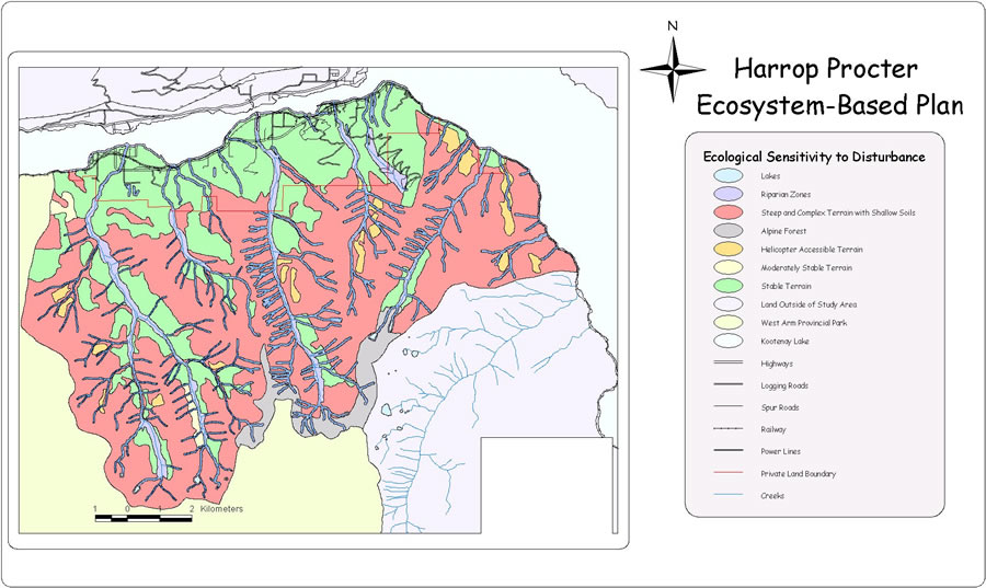
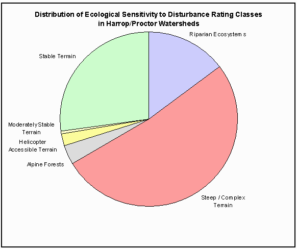
Ecological Sensitivity to Disturbance
Map Chart
Silva uses an Ecosystem Sensitivity To Disturbance (ESD) rating system to estimate the sensitivity of parts of the landscape to human uses. Map and air photo interpretation, coupled with field assessments, are used to determine the characteristics of the landscape through this rating system, which has been developed and refined by SFF over the past 25 years.
The ESD data layer was derived through a combination of air photo interpretation, field reconnaissance, existing information, and GIS modeling.
We used stereo pairs of 1:70,000 black and white air photos and 1:20,000 topographic maps to initially delineate sensitive areas. We used digital TRIM mapping for the area to create a digital elevation model (DEM) of the study area. The DEM was used to create a simple map showing a raster coverage of all slopes over 60%.
The riparian ecosystems were modeled by creating a variable width buffer, or reserve, around water features in the GIS, which was then added to the digitized ESD layer. Larger scale 1:20,000 black and white aerial photographs were used for a final check of all areas that had been identified as part of the potential Timber Management Landbase. Finally, a reconnaissance level field check of the photo-interpreted terrain sensitivity was carried out.
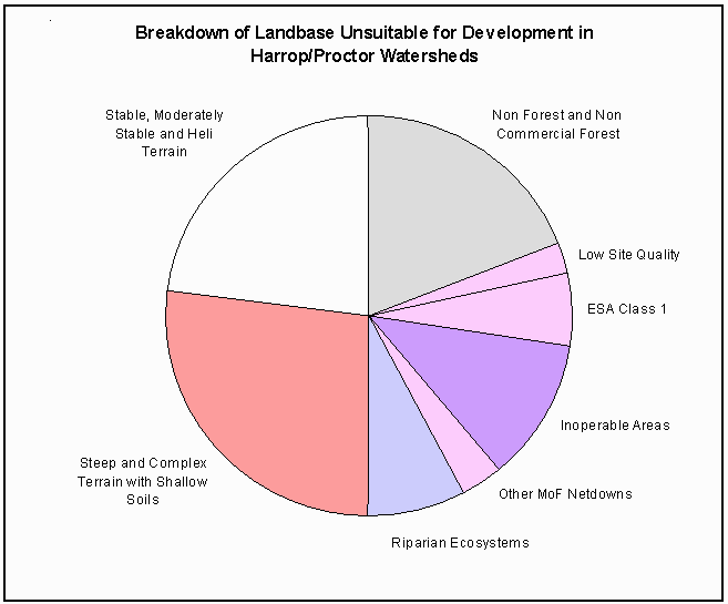
Landbase Unsuitable for Development
Map Chart
Areas in the Harrop-Procter watersheds that are judged unsuitable for timber management consist of:
- non-forested areas (per MoF);
- non-productive and non-merchantable forested areas (per MoF);
- environmentally sensitive areas (per MoF); and
- ecologically sensitive areas (per Silva).
These areas are identified and delineated using MoF forest cover maps, air photo interpretation, field assessment, and GIS analysis.
Netdowns are areas that are removed from the potential timber management area for either ecological sensitivity or economic consideration.
The following classes were identified and removed from the timber management landbase using the MoF forest cover data and the 1993 Kootenay Lake Timber Supply Analysis (TSA):
- Low Site Quality: Areas identified as having low growth potential by the MoF.
- ESA 1: Areas identified as environmentally sensitive by the MoF. Typically, these are areas with steep terrain and sensitive soils.
- Deciduous Stands: Deciduous stands are forest stands dominated by aspen, birch, or cottonwood. These tree species are marginally merchantable, and are not generally included in estimates of commercial timber productivity.
- Low Volume Stands: The TSA report identifies a matrix of stands, by species and site class, which are excluded from the landbase because their reported volume at maturity is too low to support economically viable harvesting.
- Inoperable area: These areas are considered uneconomic to harvest due to poor accessibility, high elevation, low stand volume, and/or poor timber quality.
- NSR: Areas which have been logged or disturbed, and which are currently not growing commercial tree species, but which are expected to be restocked in the future.
In the SFF Ecologically Sensitive Netdowns, two summary classes were used:
- Riparian ecosystems
- Steep and/or complex terrain
The Silva ecologically sensitive classes are only applied to areas that were not first netted out by the MoF netdowns.
The additional ecologically sensitive areas shown in Silva’s classes highlight the extent and nature of the disagreement about the net timber potential of the Harrop-Procter watersheds between conventional timber management and ecologically responsible, ecosystem-based forest management.
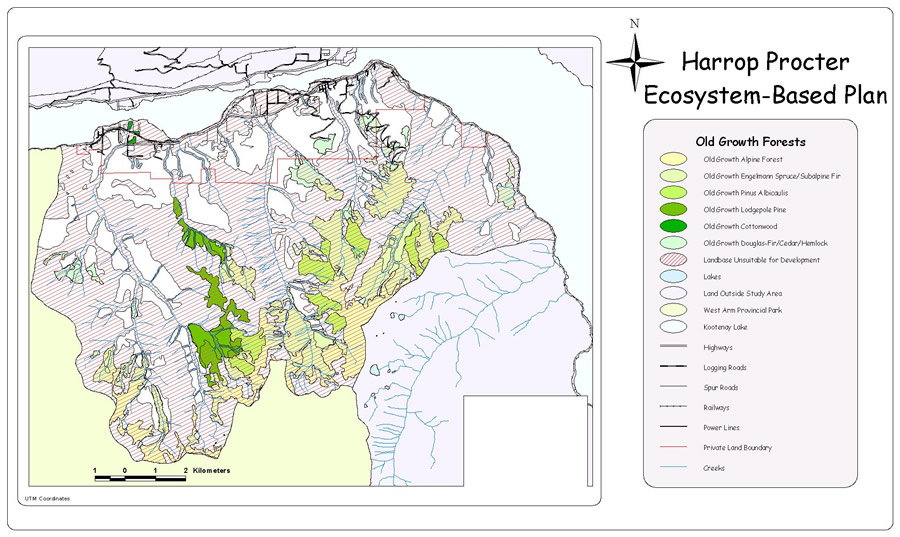
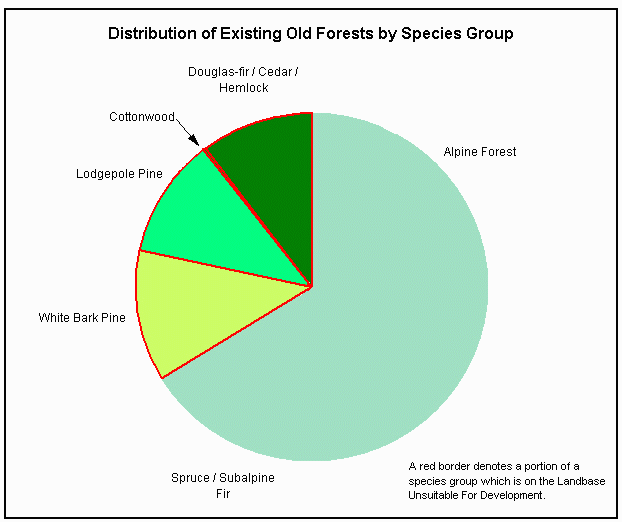
Old-Growth Forests
Map Chart
Old forests are not uncommon in the study area. Just less than 25% of the study area is occupied by old-growth forests, using strictly an age-based definition and considering all forested areas above the cutoff age as "old-growth forests". However, because different types of old forests have different characteristics, and perform different functions, this general approach is flawed. In other words, some “old forests,” as determined by age, may not have old-growth forest attributes. Similarly, some forests younger than the age cutoff may have old-growth forest attributes. The actual characteristics of old forests need to be further assessed to determine the extent of actual old-growth forests.
The map shows the distribution of old forests, or potential old-growth forests in the study area by species group and by ecological sensitivity. The chart illustrates the distribution of old forest types within the 25% of the landbase which is currently occupied by old forests. It shows that the remaining area of old forests is not evenly distributed among species groups. Some groups are over-represented, while very little old forests remain in others. Unnaturally low amounts of low elevation old-growth forests currently exist within this landscape. Restoration of low elevation old-growth forests is the urgent management need in this landscape. No one can build an old-growth forest—we lack sufficient understanding of the intricacies of soil, forest and wildlife ecology to accomplish such a feat. Thus, restoration of old-growth forests translates into "identify potential areas and leave alone".
The extensive areas included in the protected landscape network will become old-growth forests over time, barring natural disturbance. Because much of the landscape in the study area is occupied by 90 to 100 year old stands, with responsible management the transition to abundant old-growth forests will likely occur in the next century. The ecosystem-based timber management planned for the Harrop-Procter watersheds will also retain existing old-growth structures, and create more large-diameter stems within timber management areas.
SFF recommends that a thorough inventory of existing old-growth patches and structures be carried out within the lower elevations of the Harrop-Procter watersheds. Knowing the extent and location of these old forest remnants, will help future ecosystem management planning processes.
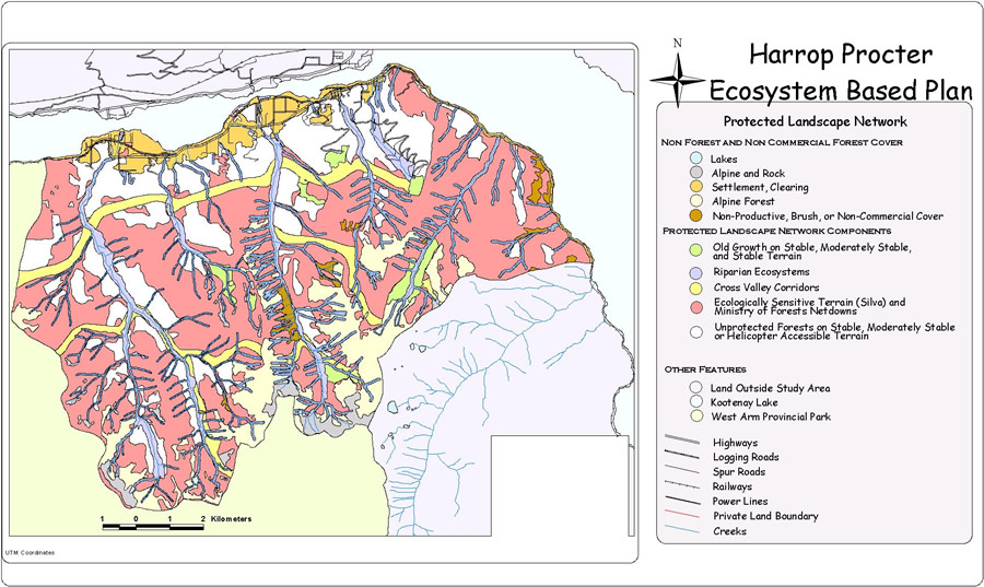
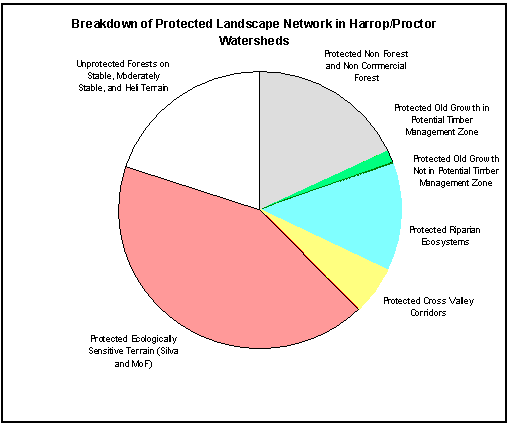
Protected Landscape Network
Map Chart
The Protected Landscape Network (PLN) combines the biophysical features and assessments shown on the Ecological Sensitivity to Disturbance map with proposed land management decisions to form a network of ecological reserve areas that extend across the Harrop-Procter watersheds. The purposes of the PLN are:
- to protect ecologically sensitive sites,
- to protect important "biodiversity hotspots" such as wetlands, riparian ecosystems and old forests,
- to protect unique habitat areas,
- to maintain undisturbed, representative natural areas within common habitat types,
- to develop additional old forest habitat throughout the landscape, and
- to maintain connections across the planning area at the landscape level.
The linkages delineated in the Harrop-Procter watersheds are generally 150 to 300 m wide. In some special locations, the linkages swell to over 800 m in order to encompass and protect an ecological feature such as a wetland complex, or to provide a protected biodiversity node on unoccupied crown land. Linkages take in a mix of stable and ecologically sensitive terrain, and attempt to encompass the range of habitat/ecosystem types found across the landscape.
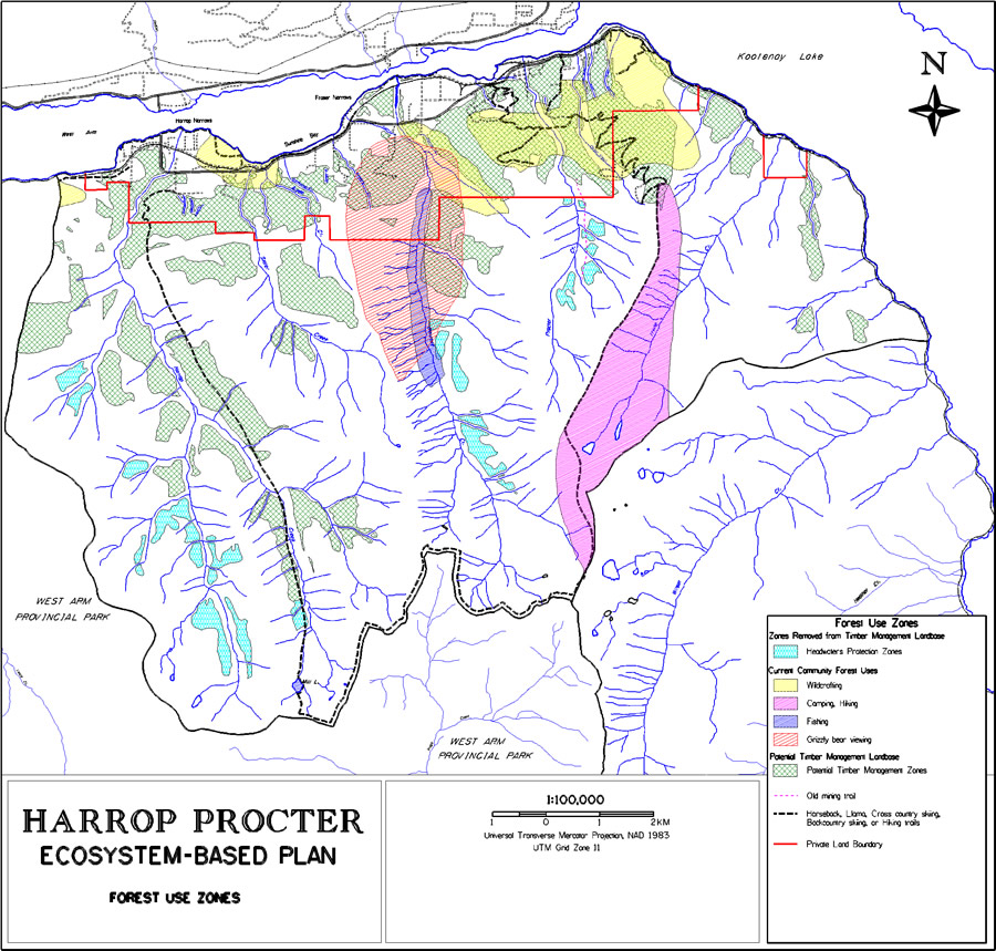
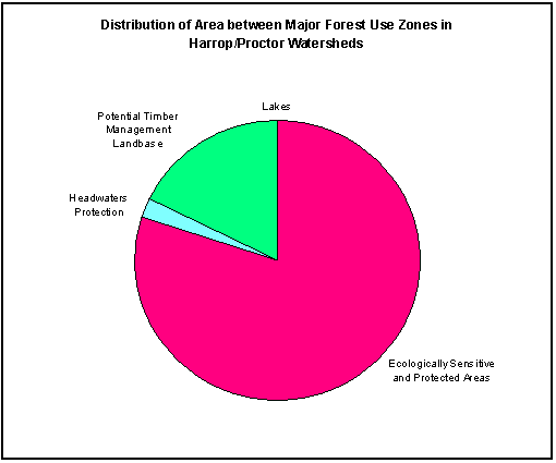
Forest Use Zoning
Map Chart
Previous steps identified the ecological framework required to protect ecosystem functioning at the landscape level, and areas that are too sensitive for aggressive human uses such as timber extraction. The end result of this process was identification of a set of areas of stable and moderately stable land which are potentially suitable for timber management. These areas are the “white patches” on the Protected Landscape Network map.
The potential conflicts between timber management and maintenance of water quality, quantity and timing of flow have been the source of an energetic debate in the Kootenay region of British Columbia, and other portions of the western cordillera for generations. Based on our analysis, discussions with the HPWPS, and review of the Harrop-Narrows-Procter Creeks Terrain Interpretation (Wallace et al 1998), we identified the following likely impacts to water resources from timber harvesting in upper portions of the watersheds in the study area:
- alteration of snowmelt patterns and spring peak flows from forest canopy alteration in the broad cirque basins in the upper reaches of Harrop Creek;
- risk of road-induced landslides into Harrop Creek if access roads are constructed through steep, sensitive terrain to reach the upper portions of watersheds;
- risk of sedimentation from surface erosion of exposed soil surfaces following road and skid trail construction; and
- risk of slope failure due to alteration and concentration of drainage patterns by roads and skid trails.
This forest use zoning is an initial exercise. Zoning changes may occur as additional field assessments are carried out, such as detailed terrain stability assessments and determination of impacts from changes in public access.
The long-term sustainable annual cutting rate in the Harrop-Procter watersheds is estimated to be 2,603 cubic meters of timber per year, on a landbase of 1,301 hectares. This is a relatively small cutting rate and timber harvesting landbase for a landscape unit of 12,967 hectares. The two main reasons for this are:
- the pattern of ownership which results in 2,271 hectares growing 3,309 m3 of timber per year being privately owned; and
- the steep, rocky, and ecologically sensitive terrain in the Crown portion of the plan area.
The Crown portion of the Harrop-Procter watersheds is almost entirely un-logged and un-accessed in 1999, after close to a century of timber cutting in southern B.C.
These areas have not been bypassed for so long because they are desirable places for logging.
The timber management landbase and cutting level identified by SFF in the Harrop-Procter EBCP strike a reasonable balance between:
- the inherent difficulties of logging in rugged terrain;
- the need to protect water and other “non-timber” forest uses;
- the need to protect and maintain natural forest ecosystem integrity; and
- community aspirations to utilize Crown timber resources as part of a diverse local economy
The cutting level is an initial estimate, based on reconnaissance level information. Much of the terrain classification work behind this estimate is based solely on air photo interpretation, and additional field assessments are required to verify or improve interpretations.
|


